For West Houston homeowners
For water damage restoration in West Houston, TX, shut off the main valve, photograph everything and start drying in the first 24 to 48 hours. Reservoir, bayou and street water is Category 3 and usually needs a professional. We take requests from the Energy Corridor, Memorial and Westchase.
Which West Houston addresses do you take requests from?
Requests for water damage restoration in West Houston, TX come from the Houston ZIP codes 77077, 77079, 77084, 77094, 77024, 77063 and 77042, plus PO boxes in Barker. This page covers the Energy Corridor, Memorial and Westchase. A restoration provider confirms whether they can reach your address when they call.
West Houston is defined more by water than by a boundary line, because two federal reservoirs and two bayous shape which homes get wet. Farther west, Katy has its own page, and Bellaire and Meyerland sit on the Brays Bayou side. Fort Bend County neighbors Sugar Land and Missouri City lie to the southwest.
What are the Addicks and Barker reservoirs?
They are two dry flood-control basins run by the U.S. Army Corps of Engineers that hold stormwater so Buffalo Bayou does not overflow downtown. Wikipedia says they are usually dry and wooded, and together they hold about 410,000 acre-feet of runoff.
The Corps completed Addicks Dam in 1948, according to the Addicks Reservoir article. The Barker Reservoir article adds that George Bush Park lies entirely inside Barker, and that Addicks and Barker provide no flood reduction benefits to properties upstream of the dams. That one sentence explains why people on the two sides of a dam describe such different experiences.
The Memorial article notes that the town of Addicks moved to the western edge of the area in the mid-1940s, after the reservoir flooded the original townsite. The system was built when this part of Harris County was rural, and houses, offices and roads have filled in around it since.
What happened in West Houston during Hurricane Harvey?
Historic rain filled both reservoirs, and the Corps released water into Buffalo Bayou to protect the dams. HCFCD says releases began on August 28, 2017. Streets and homes downstream flood when the combined release rate passes about 4,000 cubic feet per second.
The Addicks article says the reservoir peaked at 109.1 feet on August 30, 2017, its highest recorded level. HCFCD calls it the first time in the dams' 70-plus-year history that homes upstream flooded from rising reservoir water. Wikipedia says about 7,000 acres of private land upstream were deliberately submerged, and that a federal court later ruled it a taking.
The NHC's Harvey report says controlled releases were performed to prevent catastrophic dam failures, which further flooded some areas above. It also says 36 to 48 inches of rain fell across the Houston metro area. The hurricane water damage guide covers what that rain does inside a house.
Do homes above and below the reservoirs face different water?
Yes. Homes upstream, inside or beside the basins, can flood when the pool rises behind the dams, and homes downstream flood when released water pushes Buffalo Bayou out of its banks. Both are outside water, which counts as Category 3.
| Location | How water arrives | Where Wikipedia describes it |
|---|---|---|
| Upstream of the dams | Rising pool water in the reservoirs | Addicks and Barker articles |
| Eldridge Parkway corridor | Released water in Buffalo Bayou | Energy Corridor article |
| Near Terry Hershey Park and the Memorial Villages | Released water in Buffalo Bayou | Memorial article |
| Westchase and Alief | Brays Bayou, which starts near Barker Reservoir | Brays Bayou article |
The Addicks article adds that county and city authorities allowed developers to build neighborhoods on private land inside the basins, and that many residents said after Harvey they had not been told. Texas now asks sellers about this directly on the disclosure form, as the next section explains.
What is the flood risk for ZIP 77094 and ZIP 77063?
A ZIP code does not set a flood risk, and no source on this page assigns one to 77094 or 77063. Risk is set by the address: the lot, the street, the mapped zone and how close the house is to a bayou or a reservoir basin. Look up each address on its own.
- Search the full street address at FEMA's Map Service Center and save the map section.
- Open the Harris County Flood Education Mapping Tool and look at the surrounding blocks.
- Ask whether the address sits inside a reservoir flood pool, and ask your agent about flood coverage.
- If you are buying, read the seller's flood disclosure line by line.
Texas Senate Bill 339 added flood questions to the seller's notice in 2019. They include whether the seller knows of previous flooding from a reservoir release, and whether the property sits in a flood pool or reservoir. Our flood zone map guide has the full lookup steps, and buying a flooded house covers the rest.
How does Buffalo Bayou affect Memorial?
Buffalo Bayou forms the southern edge of the Memorial area, and it carries the water the reservoirs release. Wikipedia says the bayou's record levels during Harvey made Highway 6 and parts of I-10 impassable, and inundated homes in Memorial were under a mandatory evacuation.
The bayou flows 53 miles from Katy to the Gulf. According to the Buffalo Bayou article, its soils are flat and impervious, and it has broad natural floodplains. It lists four major floods since 2015: the Memorial Day Flood of May 26, 2015, the Tax Day Flood of 2016, Harvey in 2017 and Tropical Storm Imelda in 2019.
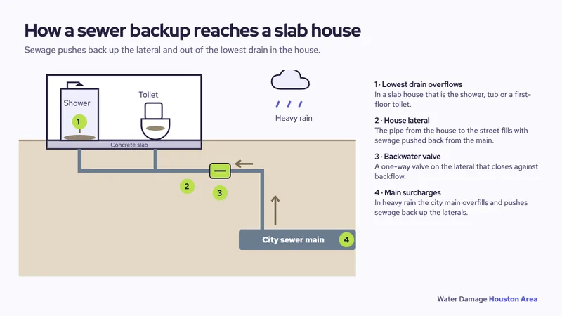
A 2024 engineering report cited there says flooding before the West Sam Houston Tollway came from the floodplain, while flooding after it was also shaped by sewage infrastructure. For a house, that is a reason to know where your sewer line drains. Our sewage backup guide explains how it reaches a slab house.
What kinds of homes and buildings does Memorial have?
Memorial was country estates and farmland before Houston annexed it between the 1950s and 1980s. Wikipedia says subdivisions arrived in the 1960s, including Nottingham Forest, Westchester and Fonn Villas, and that Memorial Bend, first developed in 1955, holds many mid-century modern houses.
Older houses mean older supply lines, older roofs and original water heaters. Many sit in the forested neighborhoods along the bayou, as Wikipedia describes them. A ceiling stain after a storm is often the first sign of a roof problem, so see roof leaks after storms.
The Energy Corridor is mostly a business district. Wikipedia says it straddles a 7-mile stretch of Interstate 10 and holds over 26 million square feet of office space. A burst line in an office floor is a different job from a house leak, and the commercial water damage page covers that side.
Is Westchase different because of Brays Bayou?
It can be. Brays Bayou has its source at a stormwater basin just south of Barker Reservoir, runs into Alief and briefly passes through Westchase, per Wikipedia. Properties near it can take bayou water, so the Meyerland and Brays Bayou story in our Bellaire page applies here too.
Westchase has a shorter history than Memorial. The Alief article says development began after 760 acres were sold to the Westchase Corporation following 1973, and Houston annexed the area in 1977. Alief itself has a flooding history: the Flood of 1899 forced many families to leave, and a flood control district was formed there in 1909.
A newer building is not exempt from leaks. AC drain lines, attic units and appliance hoses are common leak points in any house, so the AC leak guide is worth a read.
What should I do in the first 24 to 48 hours?
Stop the water, keep people safe, then start drying. The EPA says to dry water-damaged areas and items within 24 to 48 hours to prevent mold growth. If the water came from outside, treat it as contaminated and expect to need a professional.
- Shut off the main water valve, and the power to wet rooms if you can do it safely.
- Stay out of moving water. Ready.gov says six inches of moving water can knock a person down.
- Photograph and video everything before moving it, and keep receipts.
- Call your insurer. Triple-I says flood is excluded from standard homeowners policies, so ask about your flood policy.
- Call a restoration provider and ask what they will measure and how they will document drying.
- Keep indoor humidity below 60 percent, ideally 30 to 50, as the EPA recommends.
The emergency page has a longer checklist, and the insurance claims guide lists what to keep for the adjuster. Providers differ on which areas they drive to, so confirm coverage when they call.
Sources: Houston Energy Corridor; Memorial, Houston; Addicks Reservoir; Barker Reservoir; Buffalo Bayou; Brays Bayou; Alief, Houston (all Wikipedia); HCFCD, flooding impacts in connection with the reservoirs; NHC, Hurricane Harvey report; Texas Senate Bill 339; FEMA Map Service Center; HCFCD, Flood Education Mapping Tool; IICRC S500; Triple-I, disasters covered by homeowners insurance; EPA, A Brief Guide to Mold, Moisture and Your Home; Ready.gov, floods.